GeoProve was built from the ground up to work across multiple platforms and campaigns with sophisticated targeting strategies.

The Problem

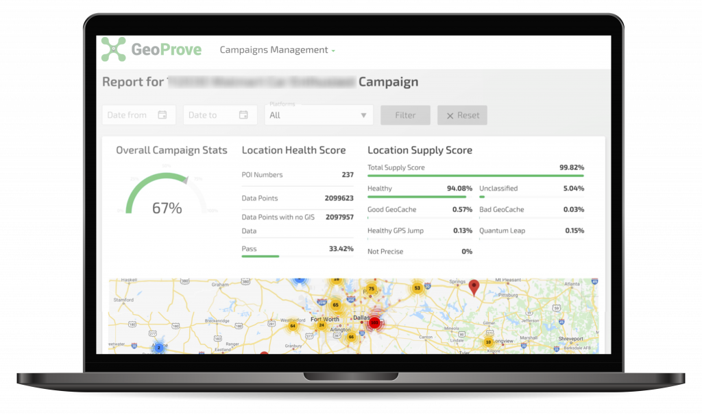
The platform has multiple checks for location data issues:

Location data in the Ad-tech Ecosystem is not without its issues. There are various sources of location data that are passed into the supply chain and often the provenance of this data is lost. It can become very hard for platforms to differentiate good data from bad data. Publishers can enjoy an increase in revenue from impressions that have location data so they will often use any source available to add location data points. For example, if a publisher has a logged in user, and has address details, they may pass the centre point of the users city in every impression – regardless of where the user currently is.

GeoProve is a platform trained on identifying good and bad sources of location data to give advertisers peace of mind that their campaigns are running exactly where they intended them.

Data Checking Process

When a location data point comes into the platform for validation we carry out a series of checks. These can be done in order or together to understand the accuracy of the signal.

Data Precision

Most advertisers are looking to reach an audience within a certain catchment area of a store or restaurant. Coordinates with two decimal places are accurate to around 1km so can’t be used for activity like this. Depending on the campaign strategy coordinates may need a resolution of three (around 100m) or four (around 10m) decimals.

Our algorithms will detect where the resolution used isn’t suitable for the campaign and score the data appropriately.

Invalid Data

Often we see errors in app developers getting location data from Android and iOS operating systems. This can be where the location is null (latitude = 0 and longitude = 0), where the latitude = longitude or where the latitude or longitude is always set to 0. These signals always look good when considered individually, but are obvious bad data when looked at over time.

Device ID Fraud

There can be a number of issues when analysing specific device ID behaviour. Normal behaviour would see a device remain in and around one large area and make long distance travel now and again. Behaviours outside a normal pattern are suspicious, take device ID 1 seen in a city at 10am then 200 miles away at 10.30am and then back near the original city at 10.45am. There are data points here that are not correct and only by analysing the device pattern over time can we see these bad data points.

Blacklisted Centroids

This algorithm catches the biggest proportion of transgressions by identifying what look like high-precision points that have been encoded using a wifi, IP, cell tower, or centroid lookup.

There are many stories showing the problems these signals can cause, they often show data points in the middle of unpopulated areas which are obviously fraudulent, however now and again they point to residential areas which can cause problems when law enforcement don’t understand the source is not accurate.

This location is the centre of the USA. The reason it gets into location data streams is when publishers know the device is in the USA but don’t have any other location data - so they default to pass the lat, long which is bang in the middle of the country. This is a centroid and can be detected and flagged as bad data.

The Solution

New Campaign

First upload a CSV. file of the POI list.

The format should be: POI Name, Lat, Long, Radius

Click ‘Extract POI’

Name the Campaign and select ‘Create Campaign’

Generate Tags

Choose ‘Generate Tag’ from the home page and select the platform or platforms you are using.

The Vendor will need to replace the macros when setting up the campaign.

Campaign Report

In the detailed report view you will see a summary of all the stats.

The Location Health Score (LHS) determines how many impressions were within the specified POI.

The Location Supply Score (LSS) detects any issues within the data.

The Overall Campaign stat is an average of both the LHS and LSS

Location Supply Score (LSS)

The LSS detects location data points which may not be accurate and most probably do not come from a GPS or wifi source. Publishers often source this data from third parties.

Get in touch for a full list of common classifications.

Location Health Score (LHS)

The LHS detects campaign configuration issues. This will show how many impressions were served outside the agreed POI.

Get in touch for a full list of common classifications.